Amazing Stargazing in the Mon
Summary
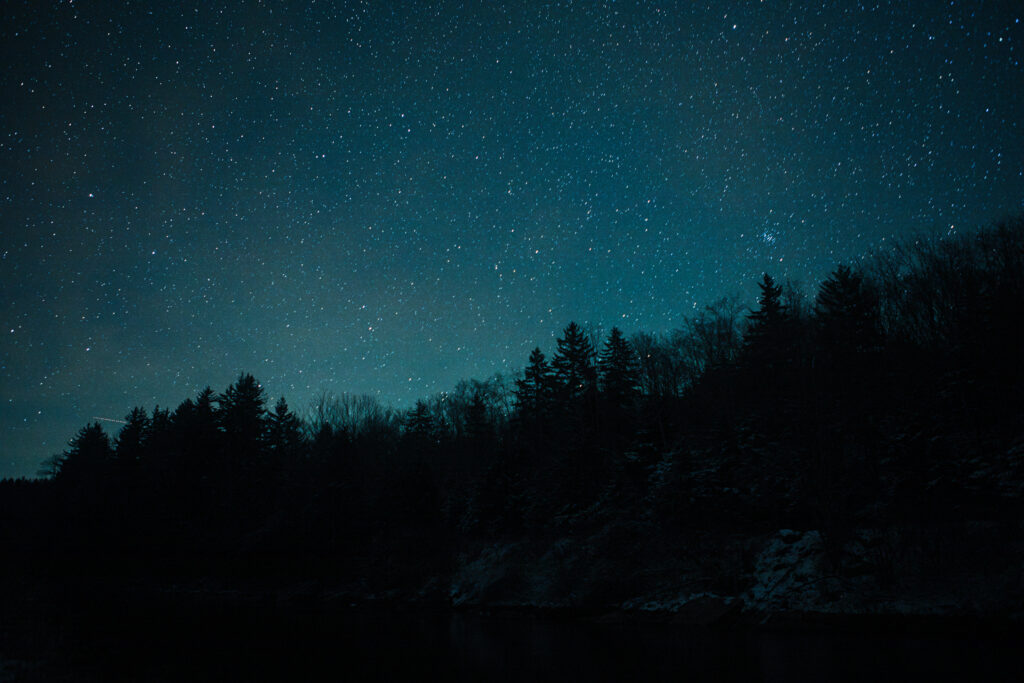
The stars shine bright in Almost Heaven, West Virginia, perhaps nowhere brighter than in the heart of our wild and wonderful Mon Forest Towns. With International Dark Sky Park recognition, we're not the only ones who love sleeping beneath the stars!
 Get Wise to Dark Skies
You don’t need to wish upon a star to find amazing stargazing in the Mon when visiting any of our forest towns, as out-of-this-world options are waiting around every bend! The stars shine bright in Almost Heaven, West Virginia, and perhaps nowhere brighter than in the heart of our wild and wonderful Monongahela National Forest. The Mon’s rugged topography, rural character, and inclusion in the National Radio Quiet Zone have culminated in one of the largest dark skies areas in the Eastern United States, enchanting visitors with stunning panoramas of the Milky Way and earning Dark Sky International’s coveted Dark Sky Park designation not once, but three times. With so many options to choose from, here are just a few of our favorites!
Remember to check the Monongahela National Forest and West Virginia State Parks‘ websites for campground availability, area closures, rules, or other alerts. Always practice Leave No Trace Principles when enjoying Almost Heaven’s amazing Public Lands!
Randolph County – Elkins
Bickle Knob
Overlooking the 20,698-acre Otter Creek Wilderness from an elevation of over 4000ft, Bickle Knob is located only 10 miles northeast of Elkins. Visitors looking to get even closer to the night sky can climb the Bickle Knob Observation Tower, initially constructed in 1933 by the Civilian Conservation Corps. The nearby Stuart Recreation Area and Bear Heaven Campground provide developed and primitive options for those who want a front-row seat to watch the stars.
Bickle Knob Parking Area Coordinates: 38.93555347564859, -79.7307590254935
Kumbrabow State Forest
Whether you are hiking the 2-mile Potato Hole Trail to the summit of Buck Knob or camping out at the Mill Creek Campground, Kumbrabow, West Virginia’s highest state forest, offers wonderful views of the Allegheny’s natural beauty by day and a breathtaking late-night light show after sunset. Approximately an hour south of Elkins, Kumbrabow is a 9,474-acre high-elevation escape from the beaten path, complete with the scenic West Virginia country roads we can’t get enough of!
Kumbrabow State Forest Visitors Center Coordinates: 38.63178019213591, -80.0852777796957
Mower Tract
While Mower Basin may be internationally recognized by day for its world-class mountain biking and hiking trail network, this Cheat Mountain Plateau is no less impressive when night falls. With dozens of dispersed camping options, this former strip mine is a testament to community-led environmental restoration and, on cloudless nights, a portal to the cosmos. Less than an hour’s drive from Elkins and Durbin, the Mower Tract is the newest best-kept secret of the Monongahela National Forest.
Mower Basin Trailhead Coordinates: 38.572006782866346, -79.92467479237905
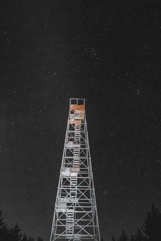
Stargazing at Barton Knob Firetower in the Mower Basin Trail System
Tucker County – Parsons, Thomas, Davis
Blackwater Falls State Park
Is there anything better than gazing at the stars while listening to the rhymic roar of one of West Virginia’s most charismatic waterfalls? We’re not sure either! If dozens of miles of hiking and biking trails, a golf course, and a sled run weren’t enough, Blackwater Falls State Park offers spectacular night sky views, no matter the season. Only 5 minutes from Davis, West Virginia’s highest mountain town, you won’t believe how quickly the wider world dissolves beneath a blanket of stars. Stargazing events are held throughout the year, so check the events calendar before your visit!
Blackwater Falls State Park Visitors Center Coordinates: 39.11258171592806, -79.48433899114471
Canaan Valley Resort State Park
A long day of hiking, biking, or winter sports doesn’t mean you have to miss out on opportunities to see the stars! With overnight options that range from camping to cabins and a full-service lodge, Canaan Valley Resort lets you take in the stars at your comfort level. Located just 15 minutes from Davis and adjacent to the US Fish & Wildlife Service’s Canaan Valley National Wildlife Refuge, this park is the premier blend of wild and wonderful West Virginia.
Canaan Valley Resort State Park Lodge Coordinates: 39.024664678653586, -79.46578253314273
Grant County – Petersburg
Dolly Sods Wilderness Area
Ascending to 4700ft, the Dolly Sods Wilderness Area is known for its strong winds and breathtaking environments, traditionally only seen in the northern reaches of Canada. Whether you are camping along Dolly Sods’ 47 miles of trails or driving to one of its scenic overlooks, stargazing opportunities abound. Less than an hour’s drive from Petersburg, Seneca Rocks, and Davis, Dolly Sods is an out-of-this-world experience for any amateur astronomy!
Dolly Sods Picnic Area Coordinates: 38.962892786076054, -79.35445095007513
Pendleton County – Seneca Rocks, Franklin
Spruce Knob
At 4,863 ft above sea level, Spruce Knob is West Virginia’s tallest mountain peak and easily one of the best places to watch the mighty Milky Way come into view! Walking along the short 1/2-mile Whispering Spruce Trail will bring visitors to the Spruce Knob Observation Tower. Constructed in 1969, this tower rises above the wind-whipped spruce and presents a panoramic view of all the stars Almost Heaven has to offer! Approximately 40 minutes from Seneca Rocks and Franklin, Spruce Knob will have you feeling on top of the world while watching the stars.
Spruce Knob Parking Area Coordinates: 38.70174818933542, -79.53104426685147
Spruce Knob Lake Campground Coordinates: 38.707760489663784, -79.58780928742192
Seneca Rocks Recreation Area
One of West Virginia’s most iconic landmarks is no less impressive after dark! With the fins of Tuscarora Sandstone jutting up nearly 900ft, Seneca Rocks is the perfect backdrop for a night of stargazing. While you might occasionally see a flashlight beam from a rock climber continuing the century-old tradition of scaling the ridge, you can enjoy the stellar procession from the Seneca Rocks Discovery Center parking lot or adjacent Seneca Shadows Campground! Within the town of Seneca Rocks and only a short drive from Franklin, this is a must-visit for anyone traveling through Pendleton County.
Seneca Rocks Discovery Center Coordinates: 38.83384961261371, -79.37438084394601
Seneca Shadows Campground Coordinates: 38.82411961898287, -79.38633205040519
Pocahontas County – Durbin, Marlinton
Lake Buffalo Recreation Area
If you want to see two times the stars, the Lake Buffalo Recreation Area is a Monongahela National Forest treasure. This tranquil 22-acre lake in Northern Pocahontas County offers dispersed camping and lets catfish anglers wet their line under the stars. For those searching for a scenic stargazing overlook, the nearby 4.5-mile Smoke Camp Trail features a monumental 1300ft climb to an old Forest Service firetower site, with a view to match the challenge. A 20-minute drive from Durbin, Buffalo Lake is an ideal retreat from the everyday.
Buffalo Lake Recreation Area Parking Coordinates: 38.532524552734934, -79.70247270358665
Gaudineer Knob Scenic Area
A stretch of old-growth high-elevation forest preserved through the region’s logging boom by a surveying error, Gaudineer Knob, or as it’s known to many, “God-is-Near Knob,” features impressive views of the Shavers Fork area. Surrounded by blankets of moss and birdsong, visitors can catch front-row seats to a world-class nighttime performance on the 0.5-mile Gaudineer Interpretive Trail. Approximately 10 minutes from the town of Durbin, it’s not hard to understand why Gaudineer Knob is considered one of the most accessible stargazing locales in West Virginia.
Gaudineer Knob Scenic Area Parking Coordinates: 38.616143904410016, -79.84376966872728
Watoga State Park
With over 10,000 acres, Watoga, West Virginia’s largest state park, received the International Dark-Sky Association’s (IDA) Dark Sky Park designation in 2o21. With 40 miles of hiking trails and the adjacent 72-mile Greenbrier River Trail, Watoga has more than enough outdoor recreation activities to fill out a full-day schedule, and there’s no better way to relax after a long day of exploration than by enjoying an awe-inspiring night sky. With campsites, cabins, and the Anne Bailey Lookout Tower bringing you even closer to the stars, the 30-minute drive from Marlinton puts you at the center of astronomical action.
Watoga State Park Visitors Center Coordinates: 38.1167193635458, -80.12777463162566
Droop Mountain Battlefield State Park
While usually a day-use park, Droop Mountain Battlefield’s Dark Sky Park hosts special Star Party events throughout the year with telescopes throughout the area, overlooking the beautiful Greenbrier River Valley. With a lookout tower, historical museum, eight short hiking trails, lodging available at the nearby Watoga State Park, and only a 20-minute drive from Marlinton, it is worth adding a visit to West Virginia’s oldest state park to your stargazing journey.
Droop Mountain Battlefield Museum Coordinates: 38.11512727849841, -80.26943174719466
Seneca State Forest
Have you ever imagined spending the night in a refurbished firetower, looking out at a wild and wonderful West Virginia sunset as the stars begin to sparkle far above you? Your dreams are already a reality at Seneca State Forest’s Thorny Mountain Fire Tower! A 30-minute and 40-minute drive from Marlinton and Durbin, respectively, West Virginia’s largest and oldest state forest has 12,884 acres of verdant Appalachian woodlands with 12 trails you can hike or bike until your heart is content. After a busy day of exploration, kick back and relax without worrying about light pollution spoiling your fun!
Seneca State Forest Visitors Center Coordinates: 38.29636229384211, -79.92910994920106
Webster County – Cowen
Bishops Knob Campground
Tucked along a high ridgetop between the Cranberry and Williams Rivers and only a 20 minutes drive from Cowen, this semi-primitive campground next to the Cranberry Wilderness Area of the Monongahela National Forest has fishing, hiking, and stargazing opportunities galore.
Bishops Knob Campground Coordinates: 38.339008314225474, -80.48889806931075
Big Ditch Wildlife Management Area
Just 3 minutes from Cowen, West Virginia’s Department of Natural Resources’ Big Ditch Wildlife Management Area offers a 55-acre warm-water lake with night fishing options and wonderful views of Webster County’s wild and wonderful woodlands. Hiking along the 3+ miles of Lake Trails will take you up a nearby bluff and, after passing through a grove of trees, presents you with an open view of the stars!
Big Ditch Wildlife Management Area Parking: 38.40849621171753, -80.57030390188825
Nicholas County – Richwood
Highland Scenic Highway Overlooks
The Highland Scenic Highway is 43 miles of breathtaking mountain scenery by day and every bit as wonderful once night falls. With scenic overlooks situated every few miles, there are too many perfect stargazing spots to count! Forming a connective route between the towns of Marlinton and Richwood, the Scenic Highway has plenty of campgrounds, hiking trails, and interpretive signs, making it one of the best adventures-per-gallon routes in the Monongahela!
Highland Scenic Highway Coordinates:
Red Lick Overlook: 38.3092751696532, -80.13772943691363
Little Laurel Overlook: 38.34087214693534, -80.16407033161693
Big Spruce Overlook: 38.26905487369973, -80.23932371192748
Williams River Valley Overlook: 38.247561235335155, -80.2407612389712
Cranberry Glades Overlook: 38.22910695106497, -80.23217114810114
Summit Lake Campground
It is hard to beat countless stars reflecting off the calm, cool waters of a high-elevation 43-acre lake in the heart of the National Forest; however, you won’t need to plan a backpacking expedition to reach this dreamy locale. Summit Lake, located just 10 miles from Richwood, offers numerous semi-primitive camping areas, night fishing, cross-country skiing trails, and hiking areas, in addition to a wonderful view of the night sky.
Summit Lake Parking Coordinates: 38.249140339877556, -80.43541275829456
Greenbrier County – White Sulphur Springs
Calvin Price State Forest
Like its northern neighbor, Droop Mountain Battlefield State Park, the 9,000-acre Calvin Price State Forest is a mostly undeveloped State Forest, relying on nearby Watoga State Park for developed recreation opportunities- however, with its recent Dark Sky Park designation, this gem of West Virginia has become a favorite for stargazers across the United States. Calvin Price State Forest will deliver amazing portraits of the sky above for those on the hunt for a more rugged stargazing adventure.
Calvin Price State Forest Coordinates: 38.066976545262236, -80.19739309827648
Greenbrier State Forest
When you pass through Harts Run Tunnel on your way to Greenbrier State Forest, you might think you’ve been transported to a whole other world! This 5,200-acre preserve, only ten minutes away from White Sulphur Springs, is the perfect place to camp out after a long day exploring historic mountain towns or catch some rest after a long day on the Greenbrier River Trail. Lying at the southernmost edge of our Mon Forest Towns region and sheltered from city lights by a shield of trees, Greenbrier State Forest is a great place to start or end your Mon Towns stargazing tour!
Greenbrier State Forest Visitors Center Coordinates: 37.75246634981279, -80.35356123315286